|
Route | WHEN OPERATIONS BEGAN
in the fall of 1895, the Conway Electric tracks ran from the Burkeville
community of Conway, near the covered bridge, to Conway Station on the
west side of the Deerfield River. Here the trolley line met the New
York, New Haven & Hartford Railroad's Canal Line. The latter
was completed in 1881 from Northampton to Bardwells Ferry, where it
joined with the Boston & Maine Railroad. New Haven trains continued
westbound over B&M tracks as far as Shelburne Falls.
In the other direction, New York, New Haven & Hartford trains would run 100.0 miles from Shelburne Falls to New Haven, Connecticut, on the former New Haven & Northampton RR, via Northampton, Westfield and Farmington. From New Haven passengers had direct connections to Grand Central Terminal in New York City.
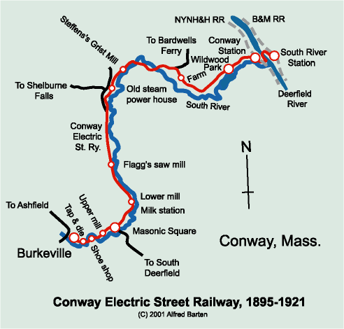
IN 1897, TROLLEY RAILS WERE EXTENDED across the Deerfield River to meet the B&M trains. The B&M, for its part, built South River Station to facilitate the meeting. This latter connection was more useful for Conway residents than the New Haven connection. It provided easy access to Greenfield, the county seat, and points east to Boston as well as points north into Vermont and New Hampshire via the various B&M branches. The B&M also provided a through route to points west of Shelburne Falls, including Charlemont, Adams, North Adams, and Troy, NY, with connections to Chicago. Service between Shelburne Falls and Greenfield along this route dates back to the Troy & Greenfield Railroad (later the Fitchburg Railroad) in 1867. The descendent line is still in operation as part of the Guilford system. In all, the Conway Electric had a route of exactly 5.91 miles of picturesque, sometimes spine-tingling single-track mainline and .59 miles of switches and sidings. The pictures and descriptions that follow are arranged to follow the route from Burkeville to South River Station. THE LINE ESSENTIALLY FOLLOWED SOUTH RIVER from Burkeville to Conway Station. It was built along the side of whatever dirt road was present. For nearly the entire route, cars running from Burkeville to Conway Station ran with the river on the right and the road on the left. For orientation purposes when looking at photographs of Conway trolleys, it is useful to note that the two combination cars always ran with the baggage end pointed towards South River Station and the passenger end pointed toward Burkeville. The line had no means for turning cars, thus the orientation never varied. When a car reached the end of the line, the motorman moved to the other end of the car and the conductor changed the direction of the trolley pole. The car was then operated back over the line from whence it came. (In normal operation the trolley pole always trails the direction of travel, though for switching operations in a yard, an electric car or locomotive might move short distances with the pole reversed. This is called "back poling.") A map drawn in 1949 by the line's chief biographer, Donald E. Shaw, shows the various sidings and principal points of interest along the way. I've based my map and discussion largely on Shaw's work. AT BURKEVILLE, the line began with two sidings, both of which extended into the car barn. Nearby was a coal siding. (Coal was seldom used in Conway before the coming of the street railway. The cost of hauling it in by teamster from Deerfield or Greenfield was prohibitive.)
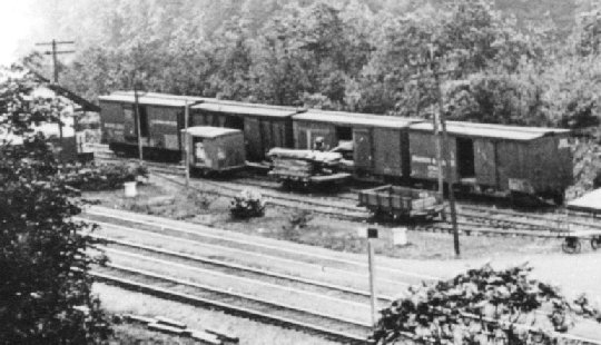
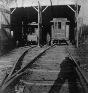
This photograph is at the Conway Electric's terminus in Burkeville. The steeple from St. Mark's Catholic Church can be seen in the background. The B&M-built; freight motor #11 is hooked up to two flat cars loaded with lumber, while one of the line's two combines (quite possibly #2) languishes beyond. The two-stall car barn is at the left. It is partially obscured by what appears to be another freight car or possibly the line (tower) car. River Street (today's route 116) is between the cars and St. Mark's.
Here's another view of the trolley barn. Photo from Alice Eldridge Collection, courtesy of the Conway Historical Society. CONTINUING EAST ALONG RIVER STREET, there was a siding at the tap & die shop (today's Orchard Equipment & Supply Co.). The line then crossed South River and turned sharply to the left, passing the shoe shop, which was located between the track and South River. Shaw's map indicates a siding for the shoe shop.
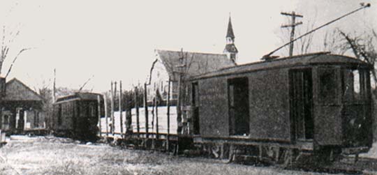
Once again the line turned sharply, this time to the right. There it crossed South River and continued with the river to its right. Just after this crossing is the site of the former upper cotton mill, now occupied by a private residence and a vacant lot often used today by residents as a place to turn their cars around. Shaw's map indicates a siding served the mill. NEXT STOP WAS MASONIC SQUARE, where a triangular green marks the intersection of River Street (which becomes Shelburne Falls Road after the crossing) and Main Street on the right (which becomes Baptist Hill Road to the left of the intersection). Today's route 116 marks the third and near side of the triangle as it turns from River Street onto Main Street. On the far corner is Masonic Hall, built in 1896 to house the post office, railway offices, and express office. (Express package service was made possible in Conway by the street railway and was a very popular service offered by New England trolley companies.) There were two sidings to the rear of Masonic Hall to handle coal, freight, and express shipments.
CONTINUING ALONG SHELBURNE FALLS ROAD, as the line swept around from a northeast direction to a northwest direction, it came to the lower cotton mill and milk station. The lower mill consisted of several builings, while the milk station included a wood-frame building and a loading platform. There was a passing siding at the milk station. None of these structures remain today. Further along the line was C.C. Flag's saw mill. This structure is now a private residence. Shaw's map does not indicate a siding at this location. JUST BEYOND the point where Shelburne Falls Road road breaks away to the left and Bardwells Ferry Road continues to the right, the trolley company built a steam-powered generating plant. This was later supplanted by a succession of two power dams, but often came in handy as a backup source of power when the river was low. There is no siding indicated on Shaw's map for the power house, but one has to wonder. This would seem like a natural place for a coal siding. A photograph published in the January 1912 issue of Western New England magazine pictures a coal siding alongside a broad meadow. This could well be at the power house. Beyond the power house but before the line swung east again to cross South River, a siding is shown at Steffens's Grist Mill. THE LINE TURNED ONTO DEPOT ROAD to continue alongside South River, by now running in an increasingly deep gorge, toward Conway Station. Depot Road has a number of steep grades, the steepest reaching 5% near the depot. A map from about this time shows the Broomshire one room schoolhouse located opposite the start of Depot Road. The schoolhouse stands today in this very spot.
Shaw's map shows a siding shortly beyond the start of Depot Road. Presumably this was for farm produce. NEAR THE POWER DAM at the east end of the reservoir, there was another siding, which served Wildwood Park.
CONWAY STATION was a classic brick station built in the New Haven Railroad's style of the day. It was accompanied by a freight house and two sidings. One of these sidings was adjacent to the electric line's siding and served as a fright transfer point between the railroad and trolley freight cars. One can still see the New Haven right-of-way, foundations, and remnants of building construction materials at this location. Some years ago I found a link from a link-and-pin coupler at this site. It is now in the Shelburne Falls Trolley Musuem collection.
THE JOURNEY ENDS with spectacular views and a hair-raising ride between the two stations. A MOST INTERESTING BIT OF ENGINEERING WORK was required to get the line across the Deerfield River to South River Station. The New Haven tracks at Conway Station were 200 feet above the Deerfield River. Immediately to the southeast of the depot the New Haven crossed South River, which joins the Deerfield at this point, by way of a spindly, 550-foot long trestle known as High Bridge. It was the highest railway bridge in the state. The Conway Electric's tracks had to duck under the New Haven tracks while clinging to the side of the embankment, then double back along the Deerfield River embankment parallel to the New Haven tracks while rapidly descending at the unusually steep grade of 8% to reach a point where it could sharply turn right and cross the Deerfield. On the other side, the line turned sharply right once more and pulled up parallel to the B&M tracks. Much of the original right-of-way, stone retaining walls, and bridge abutments and piers from both bridges are still in existence, clearly visible and in surprisingly good condition.
STEEP GRADES AND SHARP CURVES on the electric line were too severe for standard railroad equipment, thus Conway Electric's tracks never made physical connections with the steam road tracks. As a result, all goods were hand transferred between the electric line and the steam roads at Conway and South River Stations. THE LINE REACHED ITS FULL ROUTE with the 1897 expansion to South River Station. Its owners had dreams of extending the line from South River Station to Greenfield. Some of the owners were also involved in the projected Huntington and Westfield River Railway, which if undertaken and fully implemented, would have linked Conway with such far flung Western Massachusetts locales as Huntington, Cummington, Windsor, Savoy, and Hinsdale. Connections were anticipated at some of these places with other street railways that would have expanded the network even more. Wisely (easy to say in hindsight), these ventures were never undertaken. Alfred Barten, 25 February 2001.
|
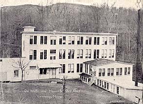 This
postcard view is of the DeWolfe and Hassell Shoe factory, also known as
the shoe shop, which once stood along River Street. It was one of a
number of factories served by the street railway. The site is now
occupied by a private residence. Some of the original stone foundations
are still in evidence.
This
postcard view is of the DeWolfe and Hassell Shoe factory, also known as
the shoe shop, which once stood along River Street. It was one of a
number of factories served by the street railway. The site is now
occupied by a private residence. Some of the original stone foundations
are still in evidence.
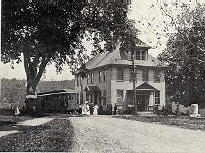 In
this postcard view, Conway Electric combine #1 pauses at the start of
Shelburne Falls Road by Masonic Hall. (River Street is in the
foregound.) This landmark structure in the center of Conway was built in
1896 and originally housed the post office, street railway offices, and
express station. Masonic Hall is now a private residence.
In
this postcard view, Conway Electric combine #1 pauses at the start of
Shelburne Falls Road by Masonic Hall. (River Street is in the
foregound.) This landmark structure in the center of Conway was built in
1896 and originally housed the post office, street railway offices, and
express station. Masonic Hall is now a private residence.
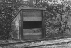 Sandbox
alongside the track. Sand was needed on the steep grade coming up from
Conway Station. Photo from Alice Eldridge Collection, courtesy of the
Conway Historical Society.
Sandbox
alongside the track. Sand was needed on the steep grade coming up from
Conway Station. Photo from Alice Eldridge Collection, courtesy of the
Conway Historical Society.
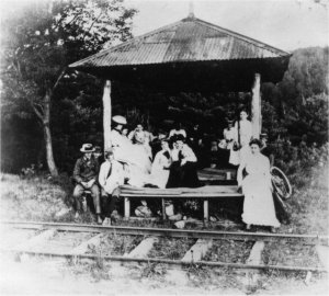 The waiting station at Wildwood park. Photo from Alice Eldridge Collection, courtesy of the Conway Historical Society.
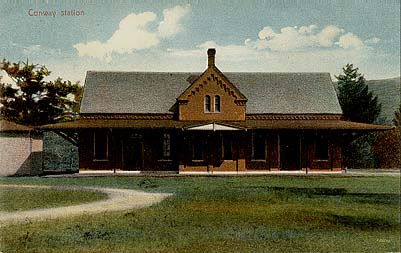 The
photograph for this postcard view must have been taken before the
Conway Electric tracks arrived in 1895 or after the electric line quit
in 1921 and was fully dismantled by August 1922. The street railway
tracks, if in existence, would have been visible in the foreground. The
New Haven tracks, though not really visible, are behind the station. The
New Haven line served Conway Station from July 13,1881 through July 18,
1923. (The color of the photograph does not mean the picture was taken
after color photography came into general use. In the early 1900s it was
common practice for an artist to hand color black and white photographs
for use in printing postcards. Most popular among the earliest of the
genre were the cards with orange-rose tinted, perfect sunset skies.)
The
photograph for this postcard view must have been taken before the
Conway Electric tracks arrived in 1895 or after the electric line quit
in 1921 and was fully dismantled by August 1922. The street railway
tracks, if in existence, would have been visible in the foreground. The
New Haven tracks, though not really visible, are behind the station. The
New Haven line served Conway Station from July 13,1881 through July 18,
1923. (The color of the photograph does not mean the picture was taken
after color photography came into general use. In the early 1900s it was
common practice for an artist to hand color black and white photographs
for use in printing postcards. Most popular among the earliest of the
genre were the cards with orange-rose tinted, perfect sunset skies.)
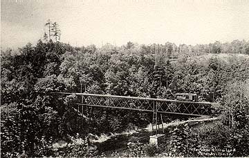 This
postcard view shows Conway Electric combine #1 crossing the Deerfield
River between Conway Station, hidden on the left by the foliage, and
South River Station, out of view on the right. Out of view to the left,
the New Haven tracks crossed over South River via High Bridge. The
Conway Electric bridge was about 300 feet long and about 120 feet above
the water.
This
postcard view shows Conway Electric combine #1 crossing the Deerfield
River between Conway Station, hidden on the left by the foliage, and
South River Station, out of view on the right. Out of view to the left,
the New Haven tracks crossed over South River via High Bridge. The
Conway Electric bridge was about 300 feet long and about 120 feet above
the water.
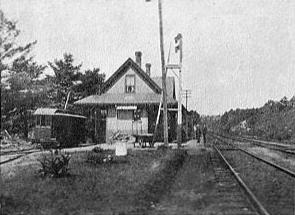 This
postcard view shows Conway Electric combine #1 on the siding at South
River Station. Nothing remains today of South River Station.
This
postcard view shows Conway Electric combine #1 on the siding at South
River Station. Nothing remains today of South River Station.